
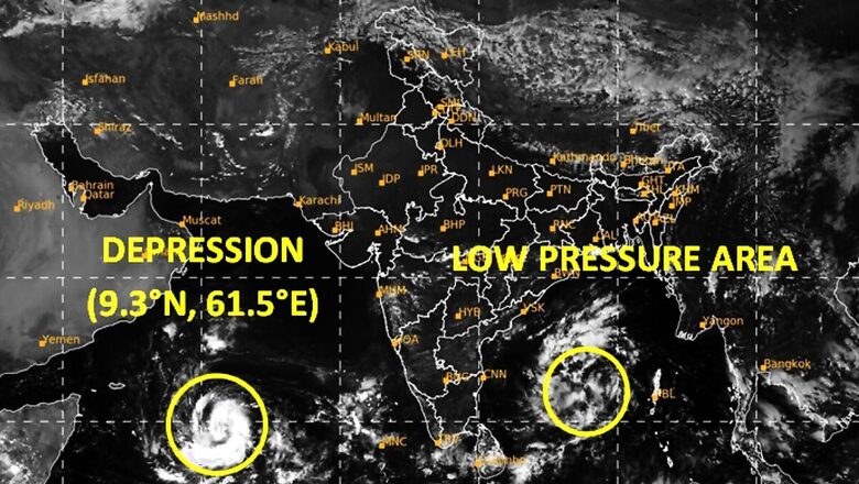
A depression over southwest Arabian Sea is expected to form into a cyclone in the next 24 hours even as a low pressure area lies over southwest and adjoining southeast Bay of Bengal, said the India Meteorological Department on Friday. The post-monsoon season’s first storm in the Arabian Sea will be called ‘Tej’ as named by India, and for now is likely headed towards Yemen and Oman and will not be a threat to Gujarat.
Daily weather briefing (English) 20.10.2023#imd #weatherupdate #india #monsoon #weatherupdate #andaman #nicobar #Kerala #Tamilnadu #bayofBengalYouTube : https://t.co/E9SJjPZ0yiFacebook : https://t.co/OKd7ecLiHh@moesgoi @DDNewslive @ndmaindia @airnewsalerts pic.twitter.com/qhDHR4zh0v
— India Meteorological Department (@Indiametdept) October 20, 2023
Cyclones, however, change their course sometimes. “It is expected to turn into a severe cyclonic storm by the evening of October 22 and move towards the south Oman and Yemen coast,” said Manorama Mohanty, director of the Meteorological Centre in Ahmedabad.
She added: “Since the cyclone would move towards west-northwest, it may not have any impact on Gujarat (which lies to the east). Weather in Gujarat will remain dry for the next seven days.”
The state’s relief commissioner Alok Kumar Pandey said as of now there was no threat as the storm was heading towards Gujarat. In June, cyclone ‘Biparjoy’ that originated in the Arabian Sea ripped through Kutch and parts of Saurashtra in Gujarat, leaving a trail of destruction. It was initially heading westward but later changed direction and made landfall in Kutch.
Here is all you need to know:
- According to the weather department, the depression over the southwest Arabian Sea moved westwards and lay centered over the same region at 11.30 am, which is about 900 km east-southeast of Socotra in Yemen and 1,170 km southeast of Oman’s Salalah airport.
- The IMD has advised fishermen not to venture into sea as the cyclonic storm is predicted to further intensify into a ‘severe’ cyclonic storm on October 22. A cyclonic storm is characterised by a maximum sustained wind speed of 62 kmph to 88 kmph, while it is termed a severe cyclonic storm if the maximum sustained wind speed reaches 89 kmph to 117 kmph.
- Meteorologists have, however, cautioned that, at times, storms may deviate from the predicted track and intensity, as seen in the case of cyclone ‘Biparjoy’, which formed in the Arabian Sea in June and initially moved in a north-northwest direction before changing course to make landfall between Mandvi in Gujarat and Karachi in Pakistan.
- Private forecasting agency Skymet Weather said a majority of models indicate the storm is heading for the Yemen-Oman coast.
- But, the Global Forecast System models suggest a recurvature while positioned over the deep central parts of the Arabian Sea, steering the system towards Pakistan and the Gujarat coast.
- The IMD further said a low-pressure area over the southwest and adjoining southeast Bay of Bengal (BOB) is likely to intensify into a depression over the west-central BOB around October 22. The system is likely to move west-northwestwards until Sunday morning and then recurve north-northeastwards towards the Bangladesh coast.
- October to December is among the favourable periods for the development of cyclones in the Bay of Bengal and the Arabian Sea due to warmer ocean temperatures.
- No tropical storm formed over the Arabian Sea during the post-monsoon season in 2022. In contrast, the Bay of Bengal saw two tropical storms, ‘Sitrang’ and ‘Mandous’.
- Skymet Weather said cyclones in the Arabian Sea have a history of uncertain tracks and timelines, and meteorologists often struggle to decisively predict their subsequent movements.
- Typically, once they are over the central parts of the Arabian Sea, the preferred track is towards Somalia, the Gulf of Aden, Yemen and Oman. But, on some occasions, these cyclones take a detour and head towards the Gujarat and Pakistan coastline.
Why the name ‘Tej’?
Cyclone ‘Tej’ has been named by India as per a formula followed for naming cyclonic storms in the Indian Ocean Region. It features in the list of names adopted by the WMO/ESCAP panel in April 2020.
Cyclone names are chosen every few years by 13 member countries and adopted in a sequence. The names must be neutral and cannot hurt the sentiments of any community in any way. They must be short, easy to pronounce and have eight or fewer letters.
Once the names are picked by the member countries, they are used in a column-wise format in a sequential order. The cyclonic storm occurring after ‘Tej’ will be Iran-named ‘Hamoon’. ‘Biparjoy’, which came before ‘Tej’ was picked by Bangladesh.
(With PTI inputs)


Comments
0 comment