views
If you hate summers, this month has turned out to be quite good so far with temperatures in many parts of the country yet to reach its summer levels. And there are more good days ahead with India Meteorological Department (IMD) predicting light to moderate rainfall in several regions across India.
From Saturday till Sunday morning, rainfall/thundershowers were observed in Kerala, Arunachal Pradesh, Assam, Meghalaya, West Bengal, Sikkim, West Rajasthan, Saurashtra & Kutch, Chhattisgarh, Karnataka, West Uttar Pradesh, Uttarakhand, Punjab, Haryana, Chandigarh & Delhi, Himachal Pradesh, East Rajasthan, Madhya Pradesh, Madhya Maharashtra, Marathwada, Telangana, Rayalaseema, Tamil Nadu, Puducherry & Karaikal, Lakshadweep, Nagaland, Manipur, Mizoram & Tripura, Odisha, Jharkhand, Bihar, Gujarat region and Konkan & Goa.
What Does IMD Latest Bulletin Say?
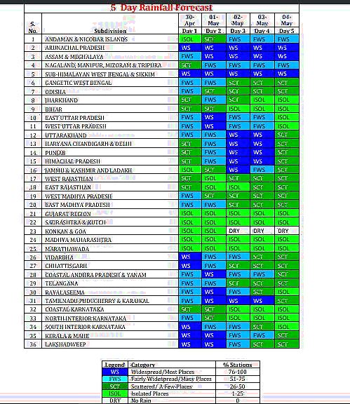
The weather forecasting agency predicted light/moderate scattered/widespread rainfall/snowfall with thunderstorm/lightning/gusty winds very likely over Western Himalayan Region and scattered to fairly widespread rainfall with thunderstorm/lightning/ gusty winds over the plains of Northwest India during the next 5 days.
It said hailstorm activity is very likely at isolated places over Himachal Pradesh and Uttar Pradesh during April 30-May 2; Uttarakhand during the next 5 days; over Punjab, Haryana, Chandigarh & Delhi, during May 1-2; over Rajasthan on April 30 and May 3.
Himachal Pradesh and Jammu are likely to witness heavy rainfall May 1-2 while duststorm is very likely at isolated places over West Rajasthan during May 3-4.
For Madhya Pradesh and Chhattisgarh, the IMD predicted heavy rainfall today. Hailstorm activity is very likely at isolated places over Madhya Maharashtra and Marathawada today
In South India, very heavy rainfall is likely at isolated places over Karnataka, coastal Andhra Pradesh, Kerala and Tamil Nadu during the next 4 days.
In East India, the IMD predicted hailstorm at isolated places over Odisha and Bihar on April 30; over Jharkhand, West Bengal and Sikkim on April 30-May 1, heavy rainfall at isolated places over Sub-Himalayan West Bengal and Sikkim during April 30-May 2 and Odisha on April 30.
1) The thunderstorm activity over most parts of the country is likely to continue till 3rd May and reduce significantly thereafter from 4th May.2) Widespread rainfall with thunderstorm/hailstorm activity and isolated heavy rainfall likely over:
— India Meteorological Department (@Indiametdept) April 30, 2023
In Northeast India, heavy rainfall is very likely at isolated places over Arunachal Pradesh and Nagaland, Manipur, Mizoram and Tripura during May 1-2; Assam and Meghalaya during May 1-4.

In the above photo, the IMD highlighted that almost all regions of India are likely to have rainfall till May 4.
Why Rain, Drop in Temperatures Across India?
The IMD outlined five major reasons behind showers in parts of the country.
- The western disturbance as a cyclonic circulation lies over central Pakistan in lower and upper tropospheric levels.
- An Induce Cyclonic Circulation over south Pakistan and adjoining West Rajasthan in lower tropospheric levels.
- A cyclonic circulation over southwest Uttar Pradesh and another over south Chhattisgarh in lower tropospheric levels.
- A trough/wind discontinuity runs from east Vidarbha to North Interior Tamil Nadu in lower tropospheric levels.
- An active Western Disturbance is likely to affect Northwest India from the night of May 1.
Pleasant April in Delhi: No Heatwave, Five Western Disturbances, Highest Rainfall Since 2017
Delhi experienced cooler temperatures in April compared to the intense heat it faced in the month last year, with frequent western disturbances leading to more rainfall and below-normal average maximum temperature.
The city recorded an average maximum temperature of 35.32 degrees Celsius in April, equal to that logged in the month in 2020, and the lowest since 2015 (34.5 degrees Celsius), according to the India Meteorological Department (IMD) .
On average, the city logs a maximum temperature of 36.5 degrees Celsius in April.
On Sunday, the national capital registered a maximum temperature of 28.7 degrees Celsius, the lowest in the month since April 4, 2015, when the mercury settled at 26 degrees Celsius.
At the beginning of April, the IMD had predicted above-normal temperatures in most parts of the country barring some parts of northwest India.
The primary weather station in the national capital, Safdarjung Observatory, also did not log any heatwave day. Last year, the city saw nine heatwave days in April, including four in the first 10 days, the highest in the month since 2010.
Kuldeep Srivastava, the head of the IMD’s regional forecasting centre, said five western disturbances (WDs), including two strong ones, kept temperatures in check in northwest India, including Delhi.
Usually, Delhi records three to four WDs, which are one of the primary sources of precipitation in the pre-monsoon season (March to May) in northwest India, in April.
The WDs yielded 20.1 mm of rainfall in Delhi in the month, the highest after 26.9 mm recorded in 2017.
Srivastava said another WD will start influencing weather in the plains of northwest starting Monday.
The IMD had on Friday said that northwest India is likely to record below-normal maximum temperature and heat wave days in May.
(With PTI inputs)
Read all the Latest India News here


Comments
0 comment