views
MapmyIndia, India’s digital maps and deep-tech geospatial company, has announced the addition of a new road safety feature called Junction View within navigation in the free Mappls app, which is available for iOS and Android users.
The new feature was introduced to reduce confusion during driving and help people navigate confidently while approaching flyovers or junctions or forks. According to the company, it is a unique feature that Indian users do not get from foreign default maps apps.
The Mappls App contains tens of thousands of junction views, with ever-expanding coverage, across thousands of cities and highways in India, including major cities such as Delhi, Noida, Gurgaon, Kolkata, Mumbai, Pune, Hyderabad, Bangalore, Chennai, Ludhiana, Lucknow, and others.
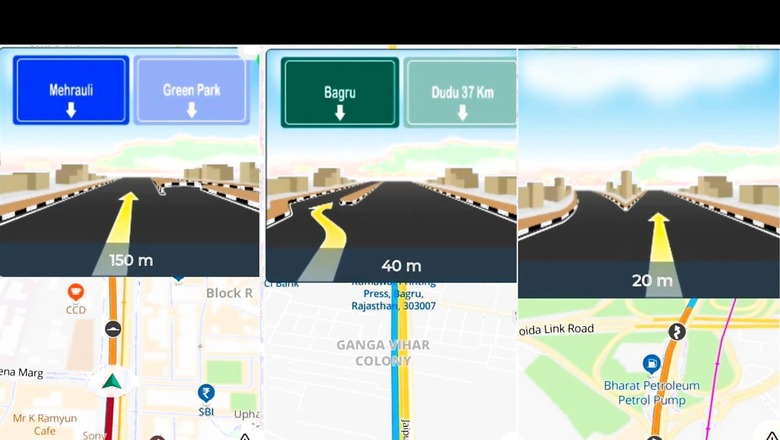
The company stated that this new feature, which helps users navigate the safest route while driving, was built after it surveyed more than 80% of drivers. What makes it different from traditional navigation apps is the fact that the driver will be directed to a route by a yellow arrow.
It is almost like the F1 Xbox game’s guiding arrow, which directs a player throughout the racing circuit. But the Mappls app’s navigation system doesn’t include all the features of the game, such as the green arrow turning red that helps the player understand a turn is coming and the break button needs to be used.
However, the app’s new navigation feature actually helps to make sudden decisions while approaching a flyover. So, for example, while using traditional apps, a driver often gets confused about the choice and sometimes they mistakenly take the wrong route because of the confusion while decoding the map’s direction. The Mappls app’s new feature provides a clear view ahead.
The junction view displays a 3D representation of the intersection with marked lanes, while navigating, the highlighted mark depicts the exit or entry of the flyover in 3D photo-realistic format. If available, the junction view displays a preview of the next junction. During navigation, tap the junction view arrow mark to close the displayed intersection.
Rohan Verma, CEO and Executive Director of MapmyIndia, said: “Nowadays, maps have become an intrinsic part of every commuter’s life calling for constant innovation to make road journeys safe. We noticed the hindrances and accidents caused by the confusion while taking the right path or turning at junctions and forks. Noticing the need, our team worked diligently to come up with this feature that will help reduce travel time, costs, hassle, and road accidents, which is critical in the Indian context.”
The company has been asking people to use the Mappls app which offers advanced safety and smart navigation features. It can be downloaded from https://mappls.com/getApp or visit https://mappls.com to use it on the web.
Read all the Latest Tech News here


Comments
0 comment